
It’s hard to go anywhere in Karnataka and not pass a long abandoned, but highly picturesque fortified place along the way. Many of these fortifications were built or significantly renovated during the Early Modern period (roughly AD 1500-1800), which was marked by chronic unrest and political instability. Many communities, especially those on the plains of the Mysore Plateau, found reason to spend the time, money, and labor that they felt was necessary to defend themselves against the threat of possible attacks.
Fort construction ended in this part of South India in the early 1800s as the political situation stabilized. Villages, towns, and cities, small and large, gradually discarded the spatial constraints and other design factors associated with defense, factors that had created the backdrop of daily life for centuries. Today, many of the old fortifications remain part of the modern landscape because they represent the most massive parts of the built environment of the past and, as such, they are not all that easy to recycle.
South Indian fortifications have been a constant thread in my research since its beginning. I began by studying the roles that many Early Modern forts played as symbols of the status and legitimacy of the kings and chiefs of the period. A key problem faced by many rulers who pretended to greatness was often precisely that—their greatness was mere pretense (and their very lives were at risk) unless they constructed for themselves an image of legitimacy and high status that was accepted in the villages and temples and at least tolerated by competing kings or chiefs in adjacent regions. One highly visible means by which a fiction of legitimacy and status could be created and maintained, a way used in many different times and places throughout the world, was to build forts. They organized labor, displayed the greatness of the chief, impressed the villagers, and—in the worse case scenario—successfully defended the king or chief against attack. The results of this study were reported in several articles, including one on Chitradurga, which I co-authored with my late colleague C. S. Patil.
From the ruler’s perspective on defense, I turned next to that of villagers. I tried to identify how Early Modern villagers in the Karnataka maidan, or plains, region viewed defense and to understand the different ways in which small communities met this challenge. This study formed the basis for my article entitled “Village Defenses of the Karnataka Maidan, South India, A.D. 1600-1800”, which was published in 2009 (South Asian Studies 25:91-111).
Most recently, I moved back to the other end of the scale of fort complexity and examined one important class of major defensive works, the hill fort. This study was made possible by the fortuitous discovery in a British archive of a detailed 1802 survey of Mysore hill forts, so detailed in fact that one could enumerate the composition, construction, and state of repair of individual walls, the material and condition of every door, and the quantity of every material object in each garrison down to such things as horseshoe nails and gunflints. The comparative analysis of these forts was published in 2012 in an article entitled “Tipu Sultan’s Hill Forts in Northern Mysore: British Assessments of the Fortifications, Buildings, Ordnance, and Stores, 1802” (International Journal of Historical Archaeology 16:164-198).
Example Forts
It may be useful to illustrate my remarks about forts with some examples drawn from my field research. Here are some well-preserved Chitradurga District forts, ranked roughly in descending order of settlement size and regional importance.
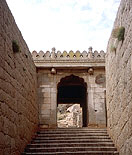 Chitradurga
This is the largest and most historically significant fort in the district. The surviving works crown several hills on the west side of the modern town of Chitradurga and are among the most well preserved Early Modern period fortifications in Karnataka. A national protected monument, the site is well-maintained by the Archaeological Survey of India.
Little is known about the extent to which the site was fortified prior to the 14th century, but there is every reason to believe that the existing works are only the latest and most extensive of a long history of fortifications at Chitradurga. It was the headquarters town of the Chitradurga nayakas until 1779 when it was taken by Haidar Ali. Many of the existing works appear to be the product of his French military engineers. Chitradurga fell to the British after the death of Tipu Sultan in 1799, but they made few changes and additions. It was garrisoned for a while, but proved to be an unhealthy station for British troops and the garrison was withdrawn by 1809, at which time it reverted to Mysore control.
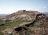 Kanakuppa
Kanakuppa is a large fortified town in Jagalur taluk. It is also an extraordinarily picturesque site and, while it lacks the size and complexity of Chitradurga, it is easily its equal in dramatic scenery. The main fortifications cover the crests of three neighboring hills. The northern and southern curtain walls extend down the hills and define a well-protected saddle area between them. Within these walls are the well-preserved remains of a town that served as the taluk headquarters until 1868, when it was shifted to the town of Jagalur, which lies about 6 km to the southeast. The town within the fort walls was soon abandoned and two new Kanakuppas grew up, one to the north of the hills and the other to the south.
Like Chitradurga and Hosdurga in southwestern Chitradurga district, an important aspect of the complexity of the fortifications at Kanakuppa is simply the amount of surface relief that the works encompass. Although most of Kanakuppa town was protected by only one line of curtain wall, the defensive use of the neighboring hilltops, the siting of bastions, and the nested wall lines that protected the two citadel areas made the most of the natural defensive characteristics of the terrain. Whoever designed the works at Kanakuppa intended to emerge the victor from any assault on the town.
 Uchchangipura
The fort at Uchchangipura occupies a low hill just west of the village of the same name in Jagalur Taluk. Although now abandoned and virtually unused except as a source of building stones, local residents report that the village was inside the fort until a few generations ago. It was then moved south of the fort to a bare ridge that placed it closer to the tank. Later, it was shifted to its present location when an all-weather road was built to the east of the fort.
Uchchangipura is easily confused with Uchchangidurga, a much larger and historically important Early Modern fort that lies about 15 kilometers to the west in Bellary District. The confusion extends even to the local populace—if you ask for directions to Uchchangipura, you inevitably get a question in response: do you mean Uchchangipura or Uchchangidurga? The fort described here gets its name from the name of a local goddess, Uchchangamma, an ancient temple for whom lies immediately to the west of the northwestern corner of the fort.
The basic plan of this fort is that of a rectangle with wall extensions to the east and west. A large natural tank (which looked dry in January, 1997) is also enclosed by a wall extension to the south. The latter extension is unusual and appears to be an afterthought. It is the only place in the fort in which the fortification extends to two lines. There are two bent entrance type gates, one about mid-wall on the north, the other about mid-wall on the south.
 Ramdurga
The fort at Ramdurga covers a low hill about 6 km south of Nayakanahatti, a town founded by the Hatti family of poligars. It was used as a village until a few generations ago, when the villagers moved less than a kilometer north of the fort wall to create the present village of Hosagudda, literally “New Hill.” The fort’s Siva temple, however, continues to be the village temple, although its popularity is said to have waned in early 1996 when the old pujari and caretaker, who could trace his ancestry to the Hatti Nayakas, passed away.
Ramdurga dominates the surrounding countryside, and the fort can be easily seen across the rolling open scrub and boulder-strewn fields for 4-5 km in any direction . Although dramatic in appearance when viewed from a distance, closer inspection reveals dead ground almost up to the walls on the southwest side of the fort; its design as a defensive work was fundamentally flawed.